Illegal Gold Mining in the Peruvian Amazon in 2025
Verified facts, locations, and what Loreto’s rivers reveal about the wider crisis
This longread is based only on publicly available 2025 reporting and documentation
from official institutions and named research and conservation organizations.
A single consolidated source list is provided at the end.
What 2025 made impossible to ignore
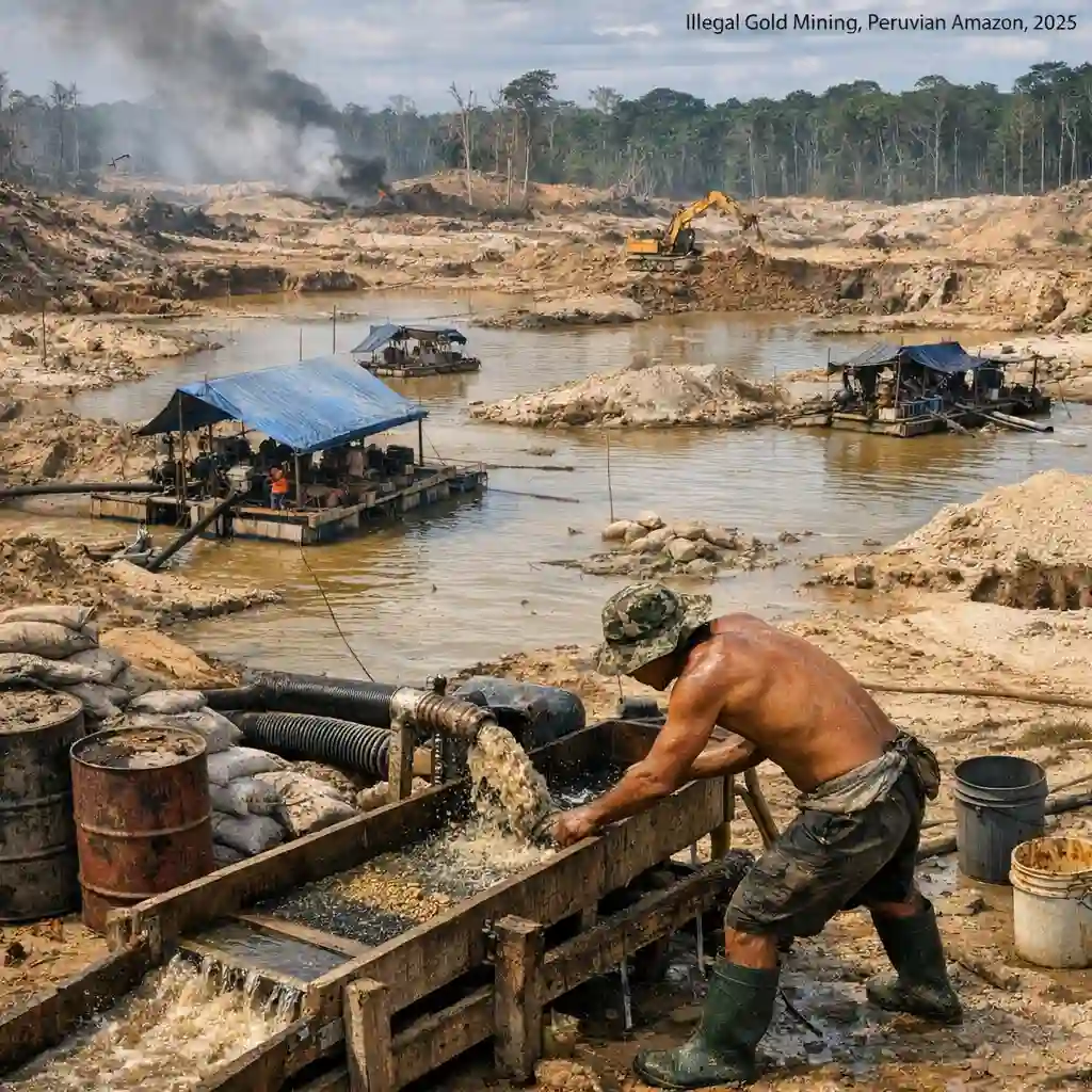
In Peru’s Amazon, illegal gold mining is not just a land issue. In 2025, it became a river issue at national scale, and a public health issue that can be measured in human hair mercury levels, not only in satellite images.
Two parallel realities were documented during 2025.
First, the national footprint is now quantifiable with a level of precision that did not exist a decade ago. Monitoring efforts using satellite imagery and field-linked datasets report that gold mining activity has affected nine Amazon regions of Peru and has left a cumulative deforestation footprint measured in the hundreds of thousands of hectares. The same monitoring work also tracks mining infrastructure in rivers, especially dredges.
Second, in Loreto, the pattern is structurally different from the well-known Madre de Dios model. In Loreto, the clearest evidence of expansion is not only forest loss on land but the rapid proliferation of dredges in blackwater and whitewater river systems, with visible geomorphological disruption and rising concerns over mercury exposure in communities whose diets depend heavily on fish.
2025 also clarified something that is easy to miss in simplified narratives. “Illegal mining” is not a single machine or a single actor. It is a supply chain and a governance problem. In the Loreto case, research and investigative reporting describe an activity that is fundamentally illegal in its main operating environment, rivers, and therefore tends to be linked more quickly to organized networks and coercive control rather than to gradual formalization pathways.
The rest of this article works from that premise and follows the evidence in three layers.
-
The 2025 national baseline, using the most widely cited monitoring figures.
-
The geography of impact, with specific administrative locations where 2025 actions and observations were documented.
-
The human consequences, using measured exposure data and documented social dynamics, while keeping the tone cautious and fact-based.
The 2025 baseline in numbers
What was measured and by whom
Multiple organizations produced 2025 summaries and reports. They differ in scope and methodology, so figures do not always match perfectly.
A major reference point is MAAP’s 2025 situation report on gold mining in the Peruvian Amazon. It consolidates deforestation footprints from gold mining and also tracks mining infrastructure in rivers, particularly dredges, for 2017–2025. MAAP also provides an estimate of affected water bodies across the Peruvian Amazon.
In parallel, the Observatorio de Minería Ilegal and its member organizations published 2025 balance summaries, including counts of affected communities and water bodies, and narrative synthesis on regional dynamics. Media outlets summarizing these materials sometimes provide additional annual or region-specific figures, which should be treated as reported summaries rather than primary measurements.
Because your goal is “facts that remain true,” this article prioritizes the primary measurements and official communications first, then uses secondary reporting to contextualize them and to add documented events and locations.
National snapshot for 2025
The most repeated national measurements from 2025 can be summarized like this.
-
Cumulative deforestation linked to gold mining in Peru, measured up to mid-2025, is reported as 139,169 hectares.
-
Madre de Dios accounts for the overwhelming share of that deforestation, reported as 97.5 percent of the total in that measurement.
-
Beyond land clearing, mining activity is documented as a river infrastructure issue, with Loreto and Amazonas standing out in dredge counts for the 2017–2025 period tracked by MAAP.
-
MAAP estimates that 225 water bodies, rivers and streams, are affected by the presence of mining infrastructure and or nearby mining-linked deforestation.
-
Other 2025 summaries state that more than 250 rivers and streams have been affected and that up to 73 Indigenous communities are impacted, reflecting a broader compilation across nine regions.
These figures are not interchangeable. They describe overlapping realities viewed through different lenses.
-
The 139,169 hectares figure is a cumulative forest loss footprint attributed to gold mining activity.
-
The dredge counts are a tally of mining infrastructure detected in rivers over a defined time period.
-
“Affected water bodies” can mean water bodies with dredges, with mining nearby, or with a broader definition of impact.
-
“Impacted communities” is a social and territorial measure, not a remote-sensing footprint.
Table of core 2025 indicators
| Indicator | What it describes | 2025 reported value | Notes on scope |
|---|---|---|---|
| Cumulative mining-linked deforestation in Peru’s Amazon | Forest loss footprint attributed to gold mining | 139,169 hectares | Reported up to mid-2025 |
| Share of deforestation in Madre de Dios | Concentration of that deforestation footprint | 97.5 percent | Indicates extreme geographic concentration |
| Dredges identified in Loreto rivers | Mining infrastructure detected in rivers | 989 dredges for 2017–2025 | MAAP tracking period |
| Dredges identified along the Nanay River | Subset of dredges in Loreto | 841 dredges for 2017–2025 | 275 detected in 2025 |
| Estimated affected water bodies in Peru’s Amazon | Rivers and streams with mining infrastructure and or nearby mining | 225 water bodies | MAAP estimate |
| Rivers and streams affected in nine regions | Broader compilation across monitoring partners | More than 250 | Reported in 2025 summaries |
| Communities impacted | Territorial and social impact measure | Up to 73 Indigenous communities | Reported in 2025 summaries |
The national picture is already severe, but it is still too abstract unless you pin it to real places. The next section does that.
Where the damage concentrates in Peru’s Amazon
Madre de Dios remains the core deforestation epicenter
From a land footprint perspective, Madre de Dios remains the main epicenter. The 2025 MAAP report attributes roughly 135,939 hectares of mining-linked deforestation to Madre de Dios by 2025, consistent with the 97.5 percent concentration figure.
The best-known hotspot within Madre de Dios is La Pampa, a mining corridor that has been repeatedly documented for years. For location specificity, La Pampa is widely described as a stretch along the Interoceanic Highway in Madre de Dios, commonly identified around kilometers 98 to 115, in the wider zone linked to the buffer area of the Tambopata National Reserve.
This matters for an evergreen article because it clarifies the structural difference between Madre de Dios and Loreto.
-
In Madre de Dios, the clearest signature is land clearing and settlement-like expansion patterns around roads.
-
In Loreto, the clearest signature is a river-based infrastructure signature, dredges in water courses and associated changes to riverbeds and floodplain systems.
Loreto is the river infrastructure epicenter
In 2025, Loreto stands out primarily because of dredge proliferation and the shift of illegal mining pressure into river basins that function as water supply systems and biodiversity corridors.
Two evidence streams converge here.
-
MAAP’s multi-year dredge detection record, which places Loreto at the top nationally in dredges detected in Amazon rivers for 2017–2025 and identifies the Nanay River as the most impacted in that dataset.
-
Loreto-focused overflights, interdiction operations, and technical monitoring reports published during 2025, which describe the expansion in operational terms and identify specific river segments and communities.
Huánuco shows a growing central Amazon front
Huánuco appears in 2025 as a meaningful deforestation front outside Madre de Dios. MAAP’s 2025 report attributes 1,262 hectares of mining-linked deforestation to Huánuco up to mid-2025 and notes that much of it is concentrated in Puerto Inca province.
Secondary 2025 summaries go further and state an annual jump from 558 hectares in 2024 to 1,700 hectares in 2025, especially affecting the Yuyapichis River. Treat that annual comparison as reported by those summaries, not as MAAP’s core statement.
Either way, the stable fact is that central Amazon basins are now part of the measurable mining footprint and are no longer peripheral in monitoring outputs.
Loreto as the key 2025 case study
Loreto is Peru’s largest region by area. Its geography is dominated by rivers and wetlands, and many communities are reachable primarily by water. That geography shapes both livelihoods and vulnerability.
In 2025, the most consequential Loreto story is the Nanay basin, not because it is the only affected basin, but because it links directly to a large urban water supply system and because it sits alongside protected areas and community territories that were designed, at least in part, to protect that water.
The Nanay basin location and why it matters
The Nanay River basin is repeatedly described in 2025 reporting as the main water source for the city of Iquitos, with a population served commonly summarized as around half a million people. The basin is also framed as exceptionally fragile in geomorphological terms, a blackwater system with low sediment dynamics that can be heavily disrupted by dredging.
Key administrative locations documented in 2025 include.
-
District of Alto Nanay, Province of Maynas, Region of Loreto. This is explicitly stated in official communications about 2025 interdiction operations.
-
The Regional Conservation Area Alto Nanay Pintuyacu Chambira, commonly abbreviated ACR Alto Nanay, which is described as located in the districts of Mazán and Alto Nanay in Maynas province and in the district of El Tigre in Loreto province.
-
The lower Nanay and associated communities named in mercury exposure work, including communities in Nanay and Pintuyacu river zones and fish markets in Iquitos used as a comparison point.
This is the level of “exact location” that can be supported cleanly by 2025 sources without guessing coordinates.
What the dredge numbers actually say
There are two compatible but distinct dredge number stories.
-
The multi-year MAAP detection story
MAAP reports that 989 dredges were identified in Loreto rivers in the 2017–2025 period. For the Nanay River specifically, MAAP reports 841 dredges identified in 2017–2025, with 275 of those detected in 2025 alone, described as 32 percent of the Nanay total for that period.
This does not mean 841 dredges were present simultaneously. It is a detection count over time. It is still powerful because it signals sustained and rising presence, and because the 2025 share is unusually large.
-
The 2025 operational count story for Loreto
A 2025 FCDS technical summary reports 688 dredges operating in Loreto in 2025, operating across 24 rivers and affecting 29 localities and communities, with 362.25 hectares of impacted area identified and a specific hotspot in the Saramiriza area with 125 hectares affected.
This is a different type of number than MAAP’s multi-year detection counts. It is presented as a 2025 operating figure and is paired with a multi-river distribution statement.
A practical way to interpret them together, without overreaching, is this.
-
MAAP establishes that Loreto is the long-run leader in detected dredge infrastructure and that the Nanay is the dominant hotspot within Loreto.
-
FCDS provides an operational 2025 snapshot that indicates Loreto’s dredging activity is not confined to a single river and is broadening across multiple basins.
What 2025 interdictions reveal about where dredging occurs
An official 2025 press release from Peru’s protected areas authority provides unusually specific location detail.
A mega-operation carried out from October 11 to October 19, 2025 in the upper Nanay basin destroyed close to 20 dredges used for illegal gold extraction, destroyed mining camps, and seized approximately 6,500 gallons of fuel. The interdictions were carried out between the communities of San Juan de Ungurahual, Pucaurco, and Alvarenga, all stated as located in Alto Nanay district, Maynas province, Loreto region.
This matters for three reasons.
-
It confirms dredging activity in the upper basin, not only downstream.
-
It ties the activity to specific communities rather than leaving it as an abstract “river problem.”
-
It shows how the activity depends on logistics like fuel, and how interdiction efforts target that dependence.
The same official statement also says that in July and August 2025, 28 dredges and seven mining camps were destroyed in that zone, suggesting repeated operations during the year.
These are not just enforcement headlines. They are geographic evidence points.
Protected areas and the governance boundary problem
The Nanay basin includes or borders protected and conservation-designated areas. Two are frequently cited in 2025 Loreto reporting.
-
The Regional Conservation Area Alto Nanay Pintuyacu Chambira, designed to protect headwaters, wetlands, and ecosystem services.
-
The Allpahuayo Mishana National Reserve, also in Loreto, often cited in broader discussions about ecosystem vulnerability and conservation around Iquitos.
2025 analysis and reporting emphasizes a boundary problem. A protected or conserved status may exist on paper, but the activity can concentrate in the gaps where protection does not apply or where enforcement presence is thin. In the Nanay basin, reporting notes that illegal dredging concentrates in areas that are easier for operators to control, where oversight is weaker, and where local economies are under pressure.
This is where the Loreto story becomes not only environmental but institutional.
Mercury and food security as measured human impact
Mercury is the simplest chemical symbol for a complicated reality. You can debate the exact origin of mercury in a region’s bodies and food chain, but you cannot debate the measurement once it is taken with documented methods and thresholds.
In 2025, two sets of mercury evidence are central for Loreto.
-
Nanay and Pintuyacu basin exposure data and interpretation, based on hair testing across multiple communities.
-
Bajo Putumayo exposure data and fish testing, framed explicitly as the highest reported levels in Loreto in that study.
Nanay and Pintuyacu hair testing results
A 2025 summary connected to CINCIA’s mercury work describes hair sample testing conducted in late 2024 across 273 people in six communities along the Nanay and Pintuyacu rivers.
Reported results include.
-
Nearly 80 percent of individuals tested had hair mercury levels above 2.2 mg/kg, the cited WHO safety threshold used in that reporting.
-
The median level across communities was 8.41 mg/kg.
-
Vulnerable groups were highlighted with specific shares at levels associated with high risk, including 45 percent of children and 37 percent of women of reproductive age.
A key point repeated in 2025 framing is that communities in these basins are highly fish-dependent, and larger carnivorous fish bioaccumulate methylmercury.
The measured human signal here is not “some people might be exposed.” It is “a large majority tested above the threshold used as reference.”
Bajo Putumayo as the highest measured levels in Loreto
A 2025 Frankfurt Zoological Society Peru release summarizes findings from the scientific study “Mercury in Loreto: human and fish exposure in the context of Amazon mining expansion.” It reports that communities in the Bajo Putumayo basin show the highest mercury levels reported in Loreto in that study’s frame.
Key reported values.
-
A mean hair mercury value of 15.67 mg/kg in Bajo Putumayo, with a range reported from 0.59 to 50.33 mg/kg.
-
97 percent of the population evaluated in Bajo Putumayo and 96 percent in Nanay and Pintuyacu exceeded the cited WHO reference limit of 2.2 mg/kg, described as chronic exposure.
-
In Bajo Putumayo, 81 percent of women of reproductive age were reported at high-risk levels, compared with 35 percent in Nanay and Pintuyacu.
-
Fish testing results reported that 32 percent of fish in Bajo Putumayo, 14 percent in Nanay and Pintuyacu, and 5 percent of fish evaluated in markets exceeded the cited 0.5 mg/kg recommended limit for human consumption in that reporting.
These are unusually concrete figures for a public-facing conservation communication. They allow an evergreen framing that is still cautious.
-
The numbers demonstrate an exposure problem that exists now, not only as a future risk.
-
The comparative structure suggests that different basins face different levels of risk, and that cross-basin and market-linked fish pathways matter.
What the fish species list implies without overclaiming
The same 2025 FZS summary lists carnivorous fish species in basins and markets that exceeded the recommended limit in their testing, including species described as bagre lince, huapeta, paiche, pez chino, and chambira.
An evergreen point you can make responsibly, without extrapolating beyond the evidence, is this.
-
In fish-dependent regions, mercury risk is not only about whether mining occurs near a specific community.
-
It is also about which fish species are being consumed, where they are caught, and how they move through markets.
This is also where the “human factor” becomes more than a rhetorical flourish. Fish is not a lifestyle choice in much of Loreto. It is protein security. When a health authority tells a region to reduce fish consumption, it is not a simple substitution problem.
How illegal mining reorganizes life in Loreto
A purely technical article can describe dredges and deforestation and stop there. But 2025 reporting makes clear that the social structure around illegal mining is part of the mechanism of expansion.
The goal in this section is not to dramatize. It is to document the patterns that 2025 sources explicitly describe.
Loreto’s distinct illegal profile
A crucial Loreto-specific distinction is repeated in 2025 investigative reporting and analysis.
In Loreto, dredging in river bodies is illegal under Peru’s legal framework. Reporting cites the prohibition on the use of dredges and similar artifacts in water bodies within the scope of small-scale and artisanal mining, emphasizing that the activity in rivers is illegal and that under the current legal framework there is no clear formalization path for it.
This matters because in regions where informal mining has a longer history, the boundary between informal and illegal can be blurred. In Loreto’s river setting, the boundary is sharper on paper, even if it is not sharp in practice.
Documented social consequences in 2025 reporting
2025 reporting on the Nanay basin describes several social consequences associated with illegal mining expansion.
-
Increased threats and intimidation for people who denounce illegal mining activity.
-
Concerns about the presence and influence of criminal networks, including transnational dynamics and cross-border basins.
-
Mentions of associated crimes such as contract killing and human trafficking as part of the broader illegal economy ecology, presented as linked to the illegal mining environment rather than as isolated incidents.
Some of these claims come from interviews and expert commentary and should be treated as reported patterns, not as quantified national statistics. The safe way to present them is to state that 2025 reporting and analysis describe these dynamics, and then focus on what is directly measurable and documentable, such as the number of dredges interdicted, the fuel seized, and the mercury levels measured.
The community voice and the ethics of exposure data
One of the most difficult aspects of mercury exposure is that it is often invisible to the exposed person.
That is why the 2025 documentation that includes community engagement is important. The 2025 FZS summary states that results were presented first to participating communities before public dissemination and that workshops were held to discuss prevention, including safer fish consumption practices.
A related 2025 summary referencing community action includes a short statement attributed to an Ikito leader speaking on behalf of Nanay basin communities, expressing the permanence of mercury exposure in their bodies if the state fails to act.
You do not need to add drama to that. The point is already stark.
When exposure is widespread and diet-linked, the human consequence includes fear, uncertainty, and a sense of lost control over something as basic as water and food.
What the state response looked like in 2025
2025 documentation describes three layers of response.
-
Interdiction operations targeting dredges and camps.
-
Regional and legal actions aimed at exclusion zones and judicial decisions.
-
Institutional and political analysis of why enforcement struggles to scale and sustain.
Interdictions and the logistics target
The October 2025 mega-operation in the upper Nanay basin is a clear example of what interdiction looks like in practice.
It involved multiple institutions including specialized environmental prosecutors, police, armed forces elements, the regional government, and protected areas authorities. It destroyed dredges, destroyed camps, and seized fuel.
Fuel seizure is not a minor detail. It points to the dependency chain. Dredging on remote rivers is not possible without a steady flow of fuel, food, spare parts, and safe routes.
Regional legal actions and citizen mobilization
2025 reporting also highlights legal and citizen actions in Loreto.
An action of amparo against a mining-related concession is described as having been declared founded in 2024 and ratified in January 2025, presented as a precedent-setting decision for Loreto. This is paired with descriptions of mobilization in Iquitos, including water defense framing and civil society involvement.
This matters because it shows that Loreto’s response is not only police-led. It includes legal contestation and urban-rural linkage through water security.
Governance vulnerability and state capture risk
A 2025 NRGI report on Loreto frames illegal mining expansion as not only an enforcement problem but also a governance problem shaped by relationships between state agents and actors linked to illegal mining.
The key points that can be summarized carefully from that 2025 material include.
-
In Loreto, much gold mining activity is fundamentally illegal, which has implications for the types of actors involved.
-
Actors linked to illegal mining can deploy influence and control strategies that limit oversight.
-
National-level political dynamics, including legislative proposals and the role of formalization mechanisms, can weaken state capacity and create ambiguity that benefits illegal networks.
This is not an accusation that “the state is captured” as a blanket claim. It is a documented analytical concern, and it is presented as a risk that varies by region and by institutional context.
The data gap problem
One repeated 2025 point is that Peru does not have a single integrated official system that fully measures and monitors illegal mining across regions and modalities. That gap is why NGOs, research institutes, and cross-institutional observatories play such a large role in quantification.
This has practical consequences.
-
It slows response coordination.
-
It creates contestable narratives where different actors cite different numbers.
-
It makes long-term accountability harder because baselines and monitoring consistency are disputed.
In 2025, the existence of multiple independent monitoring outputs is therefore both a strength and a symptom of institutional weakness.
Exact locations documented in 2025 sources
This section consolidates “where it happened” in a way that can be cited.
National scope in 2025
Gold mining activity in the Peruvian Amazon is documented in nine regions in 2025 reporting and monitoring.
-
Amazonas
-
Cajamarca
-
Cusco
-
Huánuco
-
Loreto
-
Madre de Dios
-
Pasco
-
Puno
-
Ucayali
Within those, the highest deforestation footprint is in Madre de Dios, while the highest river infrastructure signature is in Loreto.
Madre de Dios hotspot location
La Pampa, Madre de Dios, widely described as a mining corridor along the Interoceanic Highway around kilometers 98 to 115, within the broader Tambopata landscape and its buffer context.
Loreto hotspot locations
Nanay River basin, Loreto.
-
District Alto Nanay, Province Maynas, Region Loreto.
-
Communities named in official interdiction reporting for October 2025 include San Juan de Ungurahual, Pucaurco, and Alvarenga, with interdictions conducted between those communities.
Regional Conservation Area Alto Nanay Pintuyacu Chambira.
-
Stated as located in districts Mazán and Alto Nanay in Maynas province and district El Tigre in Loreto province.
-
Described as protecting headwaters and wetlands and linked to Iquitos water supply.
Bajo Putumayo basin, Loreto.
-
Framed in 2025 mercury exposure reporting as showing the highest measured levels in Loreto in the referenced study, with cross-border context implied by the Putumayo’s border geography.
Saramiriza area, Loreto.
-
Identified in a 2025 technical monitoring summary as a hotspot with 125 hectares affected within a broader Loreto operating dredge snapshot.
Huánuco hotspot location
Province Puerto Inca, Region Huánuco.
-
Identified by MAAP as the main concentration zone of mining-linked deforestation in Huánuco, with expansion along rivers including Yuyapichis cited in 2025 reporting.
What 2025 implies about risk pathways without guessing the future
An evergreen article should avoid pretending to forecast. But you can responsibly describe risk pathways that are already evidenced in 2025 documentation.
River dredging transforms the problem from local to system-wide
A road-based mining front is destructive but spatially constrained. A river-based dredging front spreads impact through water systems.
This is not only about mercury.
Dredging is described in 2025 sources as causing riverbed disturbance, sedimentation changes, and altered channels. When a river is a city’s water source and a region’s protein source, those physical changes translate into system-wide vulnerability.
Mercury turns environmental damage into personal damage
Deforestation can feel distant to someone downstream. Mercury does not.
The 2025 hair mercury data puts a number on a fear that communities often express in non-technical terms. It also shifts the policy conversation from “stop mining because of biodiversity” to “stop mining because children are being exposed above reference thresholds.”
Institutional weakness is itself an enabling condition
Loreto’s story is not that the state did nothing. Interdictions happened. Protected areas authorities issued statements. Researchers produced evidence.
The 2025 risk pathway is that enforcement without sustained institutional control is reversible. If dredges can return within weeks, the system is trapped in expensive cycles.
This is why 2025 governance analysis focuses on influence, corruption risk, and the legislative environment as factors that can neutralize field operations.
Practical takeaways for an evergreen 2025 reference
This section is intentionally action-oriented but stays within what 2025 sources support.
For readers trying to understand the crisis quickly
-
The largest cumulative mining deforestation footprint is in Madre de Dios.
-
The most documented river dredging hotspot is in Loreto, especially the Nanay basin.
-
Mercury exposure in Loreto is documented at high levels in both Nanay and Pintuyacu communities and even higher in Bajo Putumayo communities in the 2025 study summary.
-
Interdictions in 2025 targeted dredges and fuel logistics in the upper Nanay, with named communities and multi-institution participation.
For policymakers and institutions
The 2025 documentation points repeatedly to three priorities.
-
Treat dredging as a river security and water security issue, not only as an environmental crime.
-
Pair interdiction with sustained control of logistics corridors, especially fuel.
-
Build an integrated monitoring baseline that is official, transparent, and consistent across regions and modalities.
For international buyers and financial systems
A stable 2025 message from governance analysis is that upstream demand and weak due diligence amplify downstream destruction. If illegal gold can be monetized and laundered easily, interdictions in remote rivers will always be a partial solution.
This is not presented as moral commentary. It is supply-chain logic.
FAQ
How much forest was reported lost to gold mining in Peru’s Amazon by mid-2025
A major 2025 monitoring report states that cumulative deforestation linked to gold mining reached 139,169 hectares up to mid-2025.
Which region concentrated most of that deforestation footprint
The same 2025 monitoring report states that Madre de Dios concentrated 97.5 percent of the mining-linked deforestation footprint.
Why is Loreto central to the 2025 story if deforestation is concentrated elsewhere
Loreto is central because 2025 documentation highlights dredge proliferation in rivers, especially the Nanay basin, which is tied to water supply for Iquitos and to protected and conserved areas.
What is the most documented river hotspot in Loreto
The Nanay River is documented as the most impacted river in Loreto in a multi-year dredge detection dataset, with 841 dredges identified in 2017–2025 and 275 detected in 2025 alone in that dataset.
What did 2025 interdictions in the Nanay basin actually do
An official October 2025 release reports destruction of close to 20 dredges, destruction of mining camps, and seizure of around 6,500 gallons of fuel in the upper Nanay basin, between the communities of San Juan de Ungurahual, Pucaurco, and Alvarenga in Alto Nanay district.
Is mercury exposure in Loreto only a hypothetical risk
No. 2025 summaries of mercury research report that a large majority of tested individuals in Nanay and Pintuyacu communities exceeded a cited WHO reference threshold in hair mercury, and that Bajo Putumayo communities showed even higher levels in the referenced study summary.
What fraction of fish tested exceeded the recommended mercury limit in the 2025 Loreto summary
A 2025 summary reports that 32 percent of fish tested in Bajo Putumayo and 14 percent in Nanay and Pintuyacu exceeded the cited recommended limit for human consumption, with 5 percent exceeding that limit in fish evaluated in Iquitos markets in that summary.
Is mining in Loreto considered informal or illegal in 2025 reporting
2025 reporting and analysis emphasize that much of the activity in Loreto’s rivers is illegal under current law, and that Loreto does not have the same tradition of informal mining as some other regions, making river dredging a sharper legal violation on paper.
Sources
All links open in a new tab. Each item includes the publisher and publication date (when stated on the source page).
-
Situación actual de Minería de Oro en la Amazonía Peruana (MAAP #233)
Primary monitoring report used for the 139,169 ha and 225 water bodies baseline, plus dredge detection (2017–2025).
-
Amazonía bajo amenaza minería ilegal afecta 225 cuerpos de agua en 9 regiones
Secondary synthesis referencing MAAP, useful for explaining scope and regional spread.
-
225 ríos y quebradas de la Amazonía peruana están afectados por la minería de oro
Secondary report covering the MAAP 2025 baseline and explaining national distribution.
-
Loreto destruyen cerca de 20 dragas usadas para minería ilegal en la cuenca alta del río Nanay
Operational details with exact localities (San Juan de Ungurahual, Pucaurco, Alvarenga) in Alto Nanay district, Maynas province.
-
Alto Nanay una frontera estratégica y vulnerable
Investigative context on Nanay basin dynamics and governance vulnerabilities.
-
Microficha minería en el bioma amazónico occidental (Loreto dredges snapshot)
Loreto-focused monitoring summary (includes 2021–2025 active dredge counts and 2025 registrations).
-
Sobrevuelo revela dragas mineros ilegales río Nanay Perú
Independent reporting connecting overflight evidence and Loreto river mining expansion.
-
Loreto comunidades del Putumayo registran los niveles más altos de mercurio en la región
Public summary of mercury exposure findings for Bajo Putumayo and comparative basin results.
-
Mercury Research Sparks Global Attention Community Action
Narrative context and key figures from CINCIA-linked mercury testing in Nanay and Pintuyacu communities.
-
El Estado ante el avance de la minería ilegal el caso de Loreto 2020–2025
Governance analysis focused on Loreto and the structural reasons behind persistence and expansion.
-
Illegal Gold Mining A Growing Threat to the Peruvian Amazon
Broader national framing and multi-region overview with policy context.
-
Minería ilegal y poder político un estudio clave sobre Loreto y el Estado peruano
Interpretive piece highlighting political and institutional dynamics around illegal mining in Loreto.
-
Peru Faces Rising Threat as Illegal Gold Mining Expands into Nine Amazon Regions
Event-based summary citing expansion into nine regions and social-water impacts in 2025.
-
A decade on Peru’s Interoceanic Highway troubles communities
Background context for Madre de Dios and the Interoceanic Highway corridor around La Pampa.